How does it work?
MyHEAT delivers aerial thermal infrared imagery across entire cities. High resolution thermal infrared (TIR) imagery is collected quickly and economically, and then transformed using our innovative technology utilizing machine learning techniques to derive unique insight on the thermal efficiencies of every building in a city.
For our thermal data collection, MyHEAT builds on a world-class TIR sensor that integrates key benefits of traditional wide-area format digital cameras giving industry leading data fidelity and acquisition capabilities over traditional airborne cameras.
Once the thermal data is collected for a city, it is then transformed using our proprietary machine learning techniques to reveal building heat loss, and comparable efficiency metrics for the entire city. MyHEAT's pipeline includes the ability to automatically correct for local factors. This means all buildings are evaluated as if they were collected at a single instance in time, allowing heat loss to be compared over different dates as well as between homes, neighbourhoods, and cities. The result is the creation of unique HEAT Maps and HEAT Ratings for all buildings across the entire city.
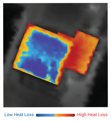
HEAT Maps
Show potential heat loss areas from a bird's-eye view. The thermal images indicate hot spots, or heat loss, in red and cooler areas in blue.

HEAT Ratings
Offer a relative measure of how much heat a building is losing compared to similar buildings in the neighborhood and city.